The Sleepy Little Town Awakes With Epic Ride Spots
Words and Photos By: Betsy Fessler


When traveling on Highway 95 through Nevada, Mina is one of the many towns north of Tonopah where you have to reduce your speed as you coast through. If you blink, you’ll miss it. It truly looks like a ghost town. But believe it or not, Mina has hidden secrets. There are hundreds of miles of trails to explore on its outskirts. And an RV park thrives on the south end of town. It is a recipe for nearly endless off-road adventures.
The Sunrise Valley RV Park is best reached through their website sunrisevalley.com. Start trying to get reservations well in advance. If you are contacting them during their off-season (roughly November through March), it can take several tries emailing or leaving messages until you hear anything back. But the owner, Chuck, runs a clean park, complete with showers, laundry, a meeting area surrounded with trail maps, and a large group fire pit.
When we arrived, we noticed the many shade trees in the campground.
Many of the sites are easy pull-through, and large enough for long rigs. When checking in at the front office, the staff was friendly and helpful. We were eager to get settled and start our weekend.
To help navigate the trails, a book is available in the office called Mina OHV Trails, written by Tom Willis. It is also available on Amazon. It is a good resource if you don’t already have access to trail maps and area history. Tom, the author, happened to be camping at the RV park when we were, so I found him and introduced myself. We are both off-roaders and writers, so we had a lot in common. Very approachable, he is a walking encyclopedia when it comes to the trails, ghost towns, and places of interest around Mina. He even offered to lead us on rides.


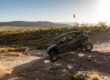
We rose with the sun the next morning, and geared up for a trip north through Powell Canyon to Hawthorne. We hit elevations of over 8,000 feet along the way. From Powell Canyon, we saw nearby Cory Peak (over 10,000 feet high) covered in snow. Lucky Boy Pass was the final leg before arriving in Hawthorne. We had a blast drifting and playing through its snow-covered canyons.
Hawthorne is best known as the location of the largest military ammunition depot in the world. As we descended from Lucky Boy Pass, we could see many of the over 2,400 storage bunkers outside of town. We ate lunch and gassed up in town, then stopped at a hunting cabin called Cow Camp and the Cabin under the Rock before returning to camp. Our muddy UTVs were evidence of a 157-mile day, fun-filled with sun, snow, and sights.
At the campfire that night, friends came by and asked us if we had ever visited Cloverdale and Orizaba. We had never heard of either, but were up for anything. Suddenly our second day was planned. We were heading east.


It took a few hours to get to Cloverdale, but it was awesome. Originally a stagecoach stop in the 1860s, the name was then changed to Cloverdale Ranch. It still remains a ranch today. Because it is off the beaten path, many of its original structures still exist, making it a great place to investigate and photograph.
Leaving Cloverdale, we diverted to see a plane crash site that another rider in our group knew of. We parked our UTV’s at the bottom of a hill and scurried up to the wreckage. Surprisingly, much of the mangled plane is still there. The story told was that the plane was transporting illegal substances, and that the occupants and pilot survived AND escaped.


From the plane crash, we rode to the Orizaba Mine, which was also very interesting. It originated in 1909 and produced gold and silver. It wasn’t very successful and was abandoned in the 1940s, but just like Cloverdale, it is remote and much of the structure is still there, including the head frame and boiler. I was also surprised to see core samples scattered all over the ground.
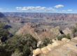
There was still gas in our Can-Am, so before returning to camp we decided to drive to Martin Spring. The spring is up a mountain trail just a few miles from the RV Park. I learned about the spring when I saw that a geocache was hidden there. We drove up, located the cache, and signed the log. While there, we were also treated to the sights and sounds of water, animal and plant life, and a nice view of Mina at sunset.


That night, we met a guy camped at the RV park named Jimmy. He is friends with Chuck and Tom and likes off-roading at an “accelerated” pace. He told us about a canyon ride that was one of his favorites and offered to take us the next day. We were game. So we packed a lunch, fueled the car, and were eager to see more new trails.
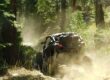
We took familiar roads for the first few miles. But then Jimmy made a turn that I don’t think I’ll ever find again. Soon after, the hills around us began to close in until we found ourselves bobbing and weaving through a shallow canyon. Slowly climbing, we eventually began seeing snow on the ground. Soon the landscape became completely white with snow, and then the hillsides opened up and crested onto a snow-kissed mountain top view. We paused for a few minutes to take in the sights. But soon enough, Jimmy took off, and we found ourselves following his tail to the next exciting and unknown destination. the next exciting and unknown destination.


I’ve heard stories of old mines in the Nevada desert that look like they are frozen in time. Mines that look like they closed yesterday and everything was left behind. I had never seen one until our trip to Mina. Jimmy led us to a lead mine, which shut down in the 1920s but almost looks like it was abandoned just a short time ago. We spent lots of time exploring there before heading back to pack, including looking through the many racks of core samples. It was fascinating.
Our group had a great time riding some of the trails of Mina, Nevada. We learned how rich in history the area is. As we said our goodbyes to the locals at the Sunrise Valley RV Park, we promised to return to see even more, including historical railroad sites, other old mining camps, and Indian petroglyphs. I can’t wait.